|
Geographic Description:
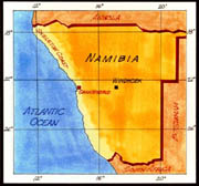 The Namib Desert parallels Africa's Atlantic Coast, from Mossamedes in Angola across the length of Namibia to the mouth of the Orange River in the Cape Province of South Africa, a distance of nearly 1,200 miles. Its width is much less, seldom exceeding 100 miles, and probably averaging between 60 and 80 miles. Its eastern border in the north and center is the foot of the Great Western Escarpment, atop which more humid lands prevail; but in the south, a gradual transition merges the Namib with the Kalahari and Karoo Deserts of the interior.
Climate:
Climatically, the Namib is a contradictory area: It is almost rainless, yet its air is normally at or near the saturation point, and fog is very common. Temperatures in the coastal area are mild at all seasons, ranging between a maximum of 67 degrees Fahrenheit and a minimum of 58 degrees Fahrenheit in the warm season (December) and between 57 degrees Fahrenheit and 46 degrees Fahrenheit in the cool (July). Inland, more continental conditions prevail, with summer temperatures reaching the 80s each day and dropping into the low 40s on the average winter night on the coast, humidity is at 100 percent for 19 hours per day in summer and for 11 hours in winter. At the inner edge of the desert, the air is much drier, fog is virtually unknown, and the humidity seldom exceeds 50 percent. This is nevertheless fairly high for a desert region. Violent weather is practically unknown. rare thunderstorms bring the precipitation, which averages less than 2 inches annually inland, and about one-half inch at the coast. Strong winds blow a few days a year from the interior, bringing heat and discomfort to the coast. But storms such as characterize mid-latitude areas are totally unknown.
Landforms:
The Namib is characterized by several distinct types of landforms: A vast sand sea, monotonously flat plains of gravel and bedrock, mountains of bare rock, and areas with surfaces fretted into strange sandblasted forms. Most of the desert consists of a broad platform, eroded into bedrock of monotonous flatness and rising in a very gradual slope from the coastline to an elevation of some 3,000 feet at the foot of the escarpment. South of the Tropic (of Capricorn), much of this platform is veneered with sand, in the form of sheets, waves, and dunes, the latter sometimes exceeding 800 feet, making them the highest sand dunes in the world. In the southern and central portions, mountains rise about the smooth platform only as isolated individuals and short chains. Most of the mountains are rugged, steep sloped, and almost soilless.
Vegetation
: In general, the Namib is a barren waste, with very sparse vegetation. Large areas, notably the gravel flats, the bedrock platform, and the dunes, are almost totally barren. In the zone of heaviest fog near the coast, especially in the south, low succulent bushes grow sporadically. Along the eastern border, a thin to moderate cover of annual grasses appears in most years, supporting for a time a variety of antelopes, zebra, ostrich, and their attendant predators.
Water Supply
: Potable water is found only as sub-flow beneath streambeds chiefly of the larger streams that rise in the rainier plateau east of the escarpment. In some cases, dissolved salts render the water unpleasant. In other cases, such as the Kuiseb and the Koichab, which supply Walvis Bay and Luderitz, the quality is good to excellent.
Settlements
: Walvis Bay has the only harbor on the Namibian coast accessible to deep-water vessels with large freighters and tankers able to come alongside the modern, efficient wharves. Fishing factories line the shore of the bay, each with its own wharf. As the only deep-water railhead in the country, Walvis Bay serves as the principal entry port for the interior. In addition to fish products, exports are chiefly minerals, wool, hides, and pelts destined for all parts of the world. Imports consist chiefly of manufactured goods, petroleum, and foodstuffs. The total population of the town is about 21,000. The water supply to the town is via a pipeline from the Kuiseb River, 23 miles to the southeast, where it is tapped from wells into the underflow of the river. Luderitz is a small-scale replica of Walvis Bay, except that its harbor is not suitable for deep-water vessels. The town's chief role is as the base for the rock lobster or crayfish industry. As a cargo port, its role is minor; its hinterland is poor and is serviced by a rail line and a single graded road. Its population is about 10,000. Its water supply also is from an underflow well mining (of the Koichab River through a 67-mile pipeline across the Namib.
Mining
: Diamonds constitute by far the most important mineral product in the territory. The diamonds are alluvial, being found in beds of gravel, usually under a considerable overburden of sterile materials. The large-scale operation of recovery of diamonds is now under one corporation: the Consolidated Diamond Mines (CDM). Because of the high value and light weight of the product and the resultant ease of theft (combined with the difficulty of rescue operations for retrieving "poachers" stranded in this extremely arid region), the entire diamond bearing area and much of its surroundings has been proclaimed a Prohibited Area (Sperrgebiet), totally closed to public entry at all times. The CDM company town of Oranjemund, at the mouth of the Orange River, is the center of diamond mining operations. It is a highly developed, progressive, modern community, with a good water supply from wells near the river and with gardens supplying fresh produce. Offshore dredging operations for the recovery of diamonds from the sea bed have been carried on.
Other minerals mined in the Namib include zinc (Rosh Pinah mine), tin and wolfram (at Uis and Brandberg Wes). Oil prospecting has been carried out in recent years, but without success.
Recreation and Tourism
: Since the time of German Southwest Africa, the coastal towns of the Namib have always had an attraction to the few and hardy. With the cooler summer climate, the fishing, the relative barrenness of the area, and its historic Germanic flavor have all been attractions for visitors.
|