|
Geographic Description:
 Amazonia is the largest tropical rain forest in the world. Originally, more than 2 million square miles of the region were covered by dense tropical forest. For centuries, its vastness and inaccessibility have protected the preponderant part of the forest, and still do so today. However, over the past 30 years, government sponsored road building projects, colonization schemes, and industrial developments have transformed large areas of Amazonia from pristine forest to polluted factory sites and sprawling settlements. This may be an ominous harbinger of things to come as the heavily exploited rain forests of Africa and Southeast Asia run out.
The River Basin:
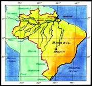
The largest of the world's rivers in terms of volume of water discharged into the sea is the Amazon. This mightiest of rivers forms a network of water channels that permeates nearly half the continent of South America. The main river is some 4,080 miles long, second only to the Nile in length. It is fed by more than 1,000 tributaries, including seven that are more than 1,000 miles long, and it drains more than half of Brazil, as well as parts of Bolivia, Peru, Ecuador, Colombia and Venezuela. Its total drainage basin of some 2,722,000 square miles and encompasses about one-0third of South America,an area more than 10 times the size of Texas and nearly as large as the entire contiguous United States. Over most of this vast region the climate is very warm and humid. Rain falls about 200 days each year, and total rainfall exceeds 80 inches per year. One result of so much rain is that Amazonia is covered by the largest tropical rain forest in the world. Another result is that the river carries by far the largest volume of water of any river in the world. On the average, some 28 billion gallons per minute flow into the sea, about 10 times the flow of the Mississippi. The discharge is so great that it noticeably dilutes the salinity of the Atlantic's waters for more than 100 miles offshore.
The great river begins as hundreds of tiny streams high in the Peruvian Andes, some of them within 100 miles of the Pacific Ocean. Rushing down the slopes, stream after stream continues to merge to form larger and larger rivers. Near Iquitos in eastern Peru, the northeastward flowing Ucayali and the Rio Maranon, the two main headwaters of the Amazon, unite to form a truly major river. Iquitos is the point farthest upstream that shallow draft-freighters and passenger vessels can penetrate (deep-water ships can reach as far as Manaus in central Brazil).
Beyond Iquitos the river changes both its character and course. Turning abruptly eastward, it more or less parallels the equator as it meanders over lowland plains. At Iquitos the river also changes its name. Locally it is known as the Solimoes from Iquitos to its junction with the Rio Negro at Manaus, and is called the Amazon only from Manaus to the sea.
Crossing the low interior basin of Brazil, the Amazon flows along a very gentle gradient: Only about 1 1/4 inches per mile. Sluggish now, it branches into numerous secondary channels, which are separated by very densely forested islands. Beyond the riverbanks are broad, swampy floodplains dotted with lakes and covered with lush, periodically flooded forests.
All along the course of the river there are seasonal floods. Tributaries flowing from the south tend to reach their highest stages from February to April, while those coming from the north tend to crest in June and July.
On its long journey to the sea, the Amazon also varies in color. Some of its tributaries are called "white" rivers, through their color is more often a murky yellow or tan. Others are known as "black" rivers, their waters dark but crystal clear. The white rivers rise in the Andes, and their turbidity results from the heavy loads of mud and silt they carry. The black rivers, in contrast, rise in areas of ancient basement rock where little sediment remains to be washed away; only dissolved organic matter stains their clarity.
Clearly the most dramatic union of a black-water stream and a white one occurs at Manaus, where the Rio Negro flows into the muddy Amazon. For many miles the black and white waters flow side by side in separate, clearly defined streams before they finally intermingle. About 600 miles from the coast, at Obidos, the ocean begins to affect the river. Tides are able to penetrate this far upstream because of the extremely gentle slope of the land.
Beyond the point where the Zingu flows in from the south, the Amazon splits up into a maze of channels clogged by larger and larger islands. (Marajo, the biggest island in the delta, is about the size of Vermont and New Hampshire combined.) Finally, beyond its several mouths, the river merges with the sea where a powerful ocean current bends it northwestward along the coast. Upon mixing with salt water and depositing brown silt along the continental shelf, the Amazon slowly loses its tan and becomes part of the much more massive South Equatorial Current. Particles of clay smaller than 4 microns, still held in suspension, tinge the current gray until it passes beyond the Guianas (French Guiana, Suriname, and Guyana). And, even after the waters clarify, dissolved nutrients from Amazonia travel as far as the Grand Banks of Newfoundland.
Cycles of Flow:
The Amazon River pulsates once a year. From November through May. the volume of the mainstream swells. For example, on June 1, 1989, the level of the river at Manaus, 900 miles from the ocean, had been 45 feet above low water, nearly reaching the 1953 all-time high-water mark on the flood gauge. The Amazon's volume in that month far exceeded the combined flow of the next eight largest rivers on Earth, as it does by the end of every May, even in years of normal flow.
During the second half of the year, the flow diminishes. By way of another example, in November 1990, around Manaus, stretches of white beaches and sandbars were exposed to the sun for the first time in living memory. The river had fallen 50 feet to its lowest level on record in this century.
The only official fluviometric studies of the main stream flow were done in 1963 and 1964 (years estimated of lesser than average rainfall) by the U.S. Geological Survey. Measurements were made at Obidos, 600 miles inland, where the Amazon squeezes through a single channel little more than a mile wide. Findings gave the average minimum discharge at 3 million cubic feet per second while the average maximum reached 8.5 million. For comparison, the Mississippi at Vicksburg averages 620,000 cubic feet per second. It has been suggested that the Amazon's average annual discharge equals 20 percent of the total continental runoff of all rivers on Earth. Note, this does not mean that the Amazon system holds one-fifth of all the world's fresh water, as some books have interpreted this data. In fact, all Amazonia's waterways hold less than one ten-thousandth of the world's fresh water, most of which is locked up in polar ice.
Settlements:
Although there are a few sizable cities along the river's banks and scattered settlements inland, Amazonia is largely uninhabited. Here and there, plantations have been cleared in the jungles, and natives ply the streams in search of latex and Brazil nuts. But mostly the great green luxuriant rain forest is still pristine wilderness, one of the few large areas left on Earth where nature's creation remains more or less unspoiled and intact.
Flora and Fauna:
The flora and fauna of Amazonia are not all known to science, since so much of them are native to the least explored parts of the rain forest. No one knows exactly how many species of fish there are in this river-sea, with estimates reported of more than 2,000. Among these are some of the biggest fish outside the ocean. (The arapaima reaches l5 feet in length and can weigh as much as 400 pounds.) Here, too, is the electric eel and the notorious piranha. And the biggest of all snakes, the anaconda, is at home here, more often in the water than out. The salt sea has contributed many inhabitants to this freshwater sea, including a dolphin, a manatee and stingrays that nestle in the sandbars high up the tributaries where they rush out of the Andes. Only a tiny percentage of Amazonia's millions of species of plants and animals are known to science, but those few that have been studied have already yielded valuable foods, medicines, and commercial products.
|