|
|
Did you know that mandala means circle? What colors would YOU use to represent the
Greatest Places in the image above? What elements? |
How do madalas ( Pronounced mahn-dah-lah
) relate to geography and place? Often the shapes in mandalas represent in an
abstract way forces of nature ( systems ) and directions ( places ). After reading
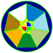
about mandalas, Josh made this mandala (left) to represent the seven greatest places.
"The blue circle is the world and the seven triangles are the seven places. The
colors I chose were based on the the most prominent geographical feature. For
instance, the dark green represents the Foliage of Madagascar & the tan represents the
sand of the Namib desert. The 7 pointed star represents the life ( plants, animals and
people ) of the places and shows how we are all interconnected. The circle in the
middle represent the traditional ideas of the elements: fire, water, air and Earth and the
four directions, north, south, east and west."
|

|
Offsite
links about mandalas:
|
|
 |
In a marriage of high tech and ancient ceremony, Tibetan Buddhist monks intricately began building a sand painting at the Museum of Fine Arts, Houston on Feb. 4, 1996. See pictures and Quicktime VR of the construction and deconstruction at the Houston Chronicle's web site. |
 Tibetan Monks answer questions about mandalas |
 Patrick A. George's Mandala page |
| Back to Tibet page | |